| Results
of expertise campaign 1999
The
full preliminary report for the work achieved in 1999 is accessible as an
extension of this site. Its contains is equivalent to the report published in
1999 under the following reference:
Blumer (R.), Vial (F.). 1999. Batpalathang,
New Archaeological Site near Jakar, Bumthang District, Bhutan: Preliminary
Report for the Investigations of April 1999. Annual Report of the
Swiss-Liechtenstein Foundation for Archaeological Research Abroad (SLFA,
Zurich, Switzerland), 1998, pp. 205-253.
The following paragraphs give an
overview of the work achieved.
B1
and B2
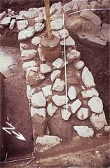
The wall
remains B2 were cleared partially. From the initial discovered stretch,
we excavated toward Southeast until the remains were totally disappearing
due to former historical dismantling. Toward the Northwest, we cleared
the remains up to a corner at right angle, from where the wall is stretching
in Northeastern direction.
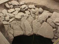
The periphery
of the underground structure B1 was apprehended through the excavation
of a sector representing about one quarter of its ground surface, i. e.
4 by 4 meters (western quadrant). The excavation permitted to document the
architecture of the dome-shaped roof of stone slabs from the outside. Moreover,
the stratigraphic profiles and the position of the stone remains within
the natural and anthropogenic sedimentary deposits were observed.
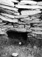
The only
excavation undertaken within the filling
of underground structure B1, consisting mostly of stones within a clayey
matrix, was to provide sufficient samples for accurate dating. Other work
done in the underground was recording the surface formed by the cylindrical
bottom wall overlaid by the slab dome-roof
in three dimensions, including the featured entrance
porch.
Underground
structure B1 is stratigraphically linked to the wall remains B2. Both share
a common occupation layer. B1 and B2 can thus be considered contemporary
and both form an archeological complex.
After
returning from Bhutan, two charcoal samples collected within the filling
of underground structure B1 were sent for radiocarbon dating (Beta
Analytic Inc., Miami, Florida, U.S.). One sample received standard
processing, whereas the second was dated by AMS method. The calibrated
average result passed the Chi-square test and indicates the end of the
8th to the begin of 9th century A.D. as the chronological setting for the
final filling of the underground structure.
The archeological
material recovered in the complex B1-B2:
-
pegged rotating millstone, upper
half fragment, gray crystalline rock (see Background
page);
-
flat millstone, gray metamorphic
rock, used secondary as construction material for the underground dome-roof;
-
shingle, wood (see Background
page) and other wood fragments;
-
rim potsherd, red-orange earthenware,
sand tempered;
-
whetstone, dark gray metamorphic
rock;
-
oxidized iron fragment;
-
string fragment, vegetal.
Eight charcoal
and cinder samples were collected for analyses. From them, two have been
dated by the radiocarbon method, and calibrated using the latest version
of OxCal.
Follow
to the 1999 results for stone platform B3. |
|
Contents
 Background
Excavated monuments
 .. back
Results 2000
News reports
Crew & assistance
How
to contact us... |